Field Trip Details
Participants take part in field trips at their own risk. They should ensure that they wear appropriate clothing and footwear and take food and drink and any required medications. See here for the Health and Safety Plan
Abel Tasman National Park
Transport by minibus and chartered boat. Max 16 pax.
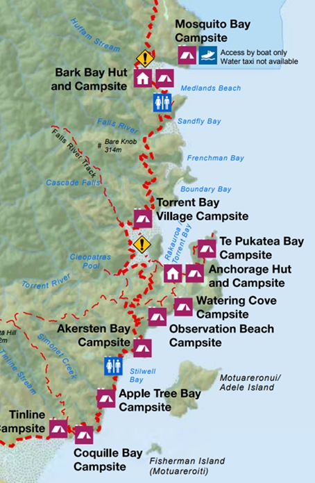
Depart Trafalgar Centre 08:00; return 17:30. Minibus from Nelson to Marahau. By boat to Anchorage; walk to Bark Bay/Wairima; return boat to Marahau.
Participants need to bring their own lunch. No packed lunch is available – you will need to make your own arrangements. There is a Countdown supermarket a few minutes walk from the Trafalgar Centre.
At 22,530 hectares Abel Tasman is New Zealand’s smallest national park. We will walk along part of the iconic Abel Tasman coastal track from Anchorage to Bark Bay/Wairima – a distance of about 10 km, with a walking time about 3-4 hours. As it will be low(ish) tide we can take a short cut across Torrent Bay (but might get a little muddy – but you can wash your boots off at a stream on the far side). This allows us to enjoy the spectacular coastal scenery as well as the birdlife – including Kaka which are now successfully breeding as a result of management intervention by DOC and Project Janszoon. On our return to Marahau in the late afternoon we will look for Banded Rails around the boardwalk across the salt marsh before boarding the minibus to return to Nelson.
For further information see:
https://www.abeltasmanbirdsong.co.nz/
https://www.janszoon.org/
https://www.doc.govt.nz/parks-and-recreation/places-to-go/nelson-tasman/places/abel-tasman-national-park/?tab-id=50578
Kahurangi National Park: Mt Arthur OR Wangapeka (access/weather dependent)
Mount Arthur
Access will be by 4×4 minibus. Limit 11 pax.
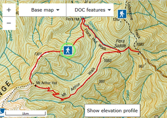
Depart Trafalgar Centre (08:00); return (17:30). Minibus from Nelson to Flora carpark.
Participants need to bring their own lunch. No packed lunch is available – you will need to make your own arrangements. There is a Countdown supermarket a few minutes walk from the Trafalgar Centre. Good footwear, plenty of warm clothes and waterproofs required.
There are two options for this trip, both providing the opportunity to see a range of beech forest birds including Rifleman, South Island Robin, Brown Creeper, Kea and Kaka and to learn about the activities of Friends of Flora who have worked in partnership with DOC for 23 years to restore biodiversity over 10,000 ha of the National Park. The volunteer group manages a network of 2684 stoat traps and have re-established Blue Duck/Whio and Great Spotted Kiwi/Roroa, with both species now spreading well beyond the project area. FOF has a comprehensive bird monitoring programme including walk-through river surveys for Whio, trail camera nest monitoring for Kea, five-minute bird counts and nocturnal acoustic monitoring. Both options will be run if there is interest.
The first option follows a well-graded 4.2 km (2.5 hrs) walking track towards Mt Arthur, winding through beech forest, groves of candelabra-like mountain neinei (Dracophyllum traversii) and limestone karst features. Mt Arthur Hut is just on the tree line – walk a bit further above the hut for views over Kahurangi and an opportunity to learn about FOF’s alpine lizard and invertebrate monitoring programme. Return via Flora Hut is a 4.5 km tramping track (2 hrs). Moderate fitness required.
The second option will be a relaxed walk down the Flora valley for up to 6 kms looking for Whio, returning by the same route.
For further information see:
https://www.fof.org.nz/
https://www.doc.govt.nz/globalassets/documents/parks-and-recreation/tracks-and-walks/nelson-marlborough/cobb-valley-mt-arthur-tableland-brochure.pdf
If Mount Arthur is not accessible (e.g. snow/road slip) the trip will go to the Wangapeka River to look for Whio/Blue Duck (subject to crossing the Dart River Ford – not possible after heavy rain!).
Wangapeka
Access will be by 4×4 minibus. Limit 11 pax.
Depart Trafalgar Centre 08:00; return 17:30.
Participants need to bring their own lunch. No packed lunch is available – you will need to make your own arrangements. There is a Countdown supermarket a few minutes walk from the Trafalgar Centre. Good footwear, plenty of warm clothes and waterproofs required.
If Mount Arthur is not accessible (e.g. snow/road slip) the trip will go to the Wangapeka River to look for Blue Duck/Whio (subject to crossing the Dart River Ford – not possible after heavy rain!).
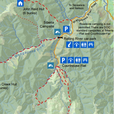
We will walk along the Wangapeka River looking for Blue Duck/Whio. The Wangapeka and Fyfe River catchments are situated within 30,000 hectares of beech forest. When DOC’s Whio programme began on the Wangapeka’s Rolling River in 2003, just three Whio lived there. By 2010 there were 65 Whio on the river (16 pairs, five single ducks and 28 ducklings). By 2021 there were 79 pairs. This Whio population is protected by over 1000 traps that target stoats and rats. In the whole of Kahurangi there are now 846 adult Whio, including 335 breeding pairs.
For further information see:
https://www.doc.govt.nz/parks-and-recreation/places-to-go/nelson-tasman/places/kahurangi-national-park/things-to-do/tracks/wangapeka-track/
The Brook Waimarama Sanctuary, Nelson
Transport by public eBus (Route 4) operated by Nelson City Council. Max 20 pax.
The bus departs from the Nelson City Centre Interchange Station, Bridge Street at 08:15. Return bus departs 12:28/13:28.
The Brook Waimārama Sanctuary is the largest fenced sanctuary in the South Island. Our guided walk may include a few steep sections of track, though there are accessible tracks and self-paced options – which can be discussed on the day. Orange-fronted Parakeet/ Kākāriki Karaka have been released into the Sanctuary and the numbers have increased spectacularly, however they mostly occur in the higher areas of the Sanctuary so we may not see them.
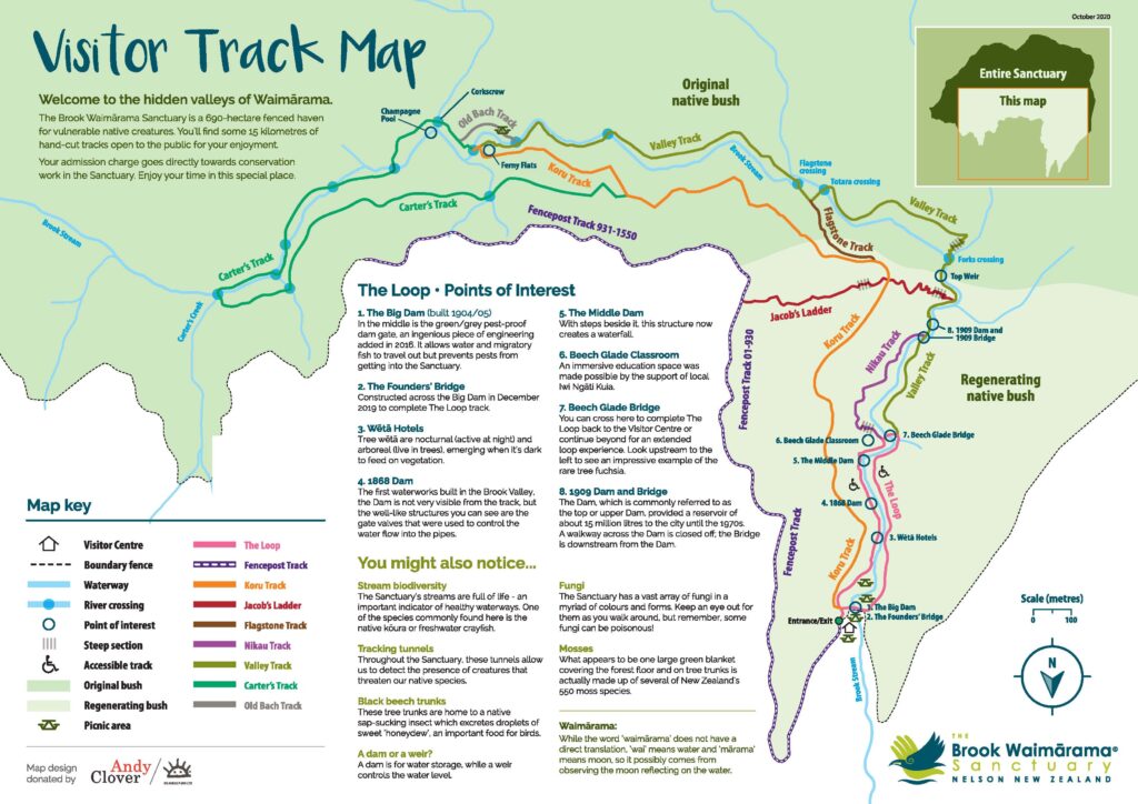
For further information see:
https://www.brooksanctuary.org.nz/
https://www.birdsnz.org.nz/wp-content/uploads/2023/11/Brook-Sanctuary-Visitor-map-scaled.jpg
Nelson Wastewater Treatment Plant
Transport by shared vehicles. Max 20 pax. per three hour session (09:00 to 12:00 and if sufficient demand, 2nd trip 12:00 to 15:00).
Meet on site at 09:00. A 10-minute drive north from Nelson City along SH6, turnoff left at the head of Nelson Haven estuary along Boulder Bank Drive (this is not signposted, but the road turning is beside a large cream two-storey house with a grey roof). Drive along Boulder Bank Drive to the Nelson Wastewater Treatment Plant office. There is limited parking in the compound; otherwise, park on the road at the Boulder Bank.
All participants must sign in at 09:00 and then attend a safety briefing. Our walk will include the created tertiary treatment wetland lagoons as well as the main oxidation ponds, which are a wetland of international importance for New Zealand Scaup. We will also explore the Wakapuaka Sandflats Reserve which supports a locally important population of Fernbird – chocolate fish prizes for anyone who photographs a colour-banded Fernbird!
If there is sufficient demand, a second trip will be run, starting at 12:00. More details are available here.
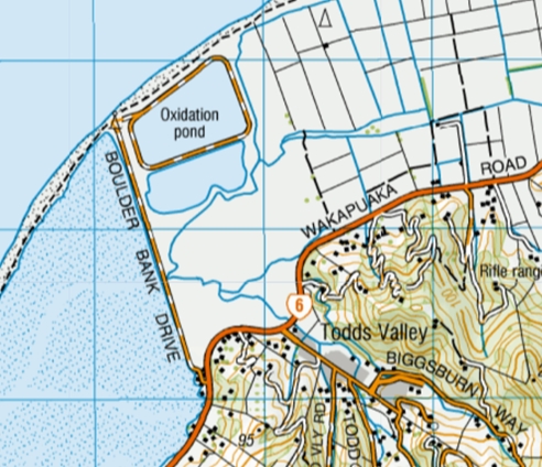
Further information:
http://www.nelson.govt.nz/services/facilities/infrastructure/nwwtp/
https://www.birdsnz.org.nz/wp-content/uploads/2022/09/Shortnote_69_Field_etal_178-182.v3.pdf
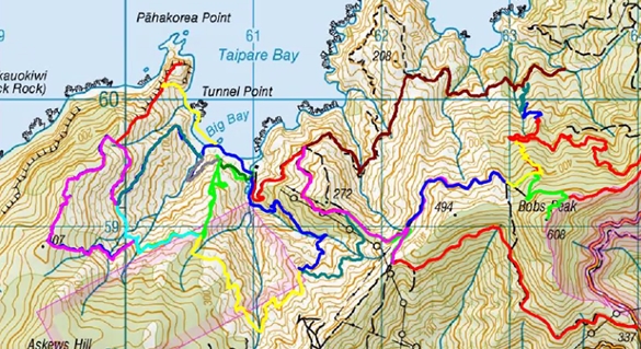
Taipare Bay, Marlborough Sounds
Transport by private car (sharing) – ideally 4-wheel drive. Max 8 pax. with 4-wheel drive – otherwise 4 pax if 2-wheel drive.
Depart Trafalgar Centre 07:00 – journey time 1.5-2 hours. Take SH6 from Nelson to Rai Valley, then turn left on to Ronga Road (signposted French Pass). Continue through Okiwi Bay and along Croisilles-French Pass Road. Detailed travel instructions will be provided to registered participants. Depart Taipare Bay 16:00.
Participants need to bring their own lunch. No packed lunch is available – you will need to make your own arrangements. There is a Countdown supermarket a few minutes walk from the Trafalgar Centre.
Rob and Anneke Schuckard have lived at this coastal property at the western fringe of the Marlborough Sounds since 1989 and would love to share a day with you on this wild coastal area. The property is part of the D’Urville Ecological District and most of this property has been submitted to the Significant Natural Area register of the Marlborough Sounds. The site was first surveyed in 1887 and includes one of the most extensive areas of coastal ultramafics in the country. A major portion has been assessed as part of the outstanding natural landscapes in the Marlborough Sounds. Occurring geologies of serpentinitic breccia but also limestone are very rare not only in the Sounds, but also nationally.
The day’s excursion will navigate these geologies using one of the pest trap lines that has been established. Views are wide and far over Tasman Bay and Abel Tasman National Park and Mt Arthur in the distance. Bird life that can be encountered are a number of introduced passerines and further Weka, Brown Creeper, Silvereye, Fernbird, Bellbird and maybe New Zealand Falcon. Due to season, coastal birds are limited to a number of shag species, Australasian Gannet, Fluttering Shearwater and gulls and terns. Of course, surprises are always possible. The trip will take about 5 hours walking from sea-level to 300 m and requires average fitness.